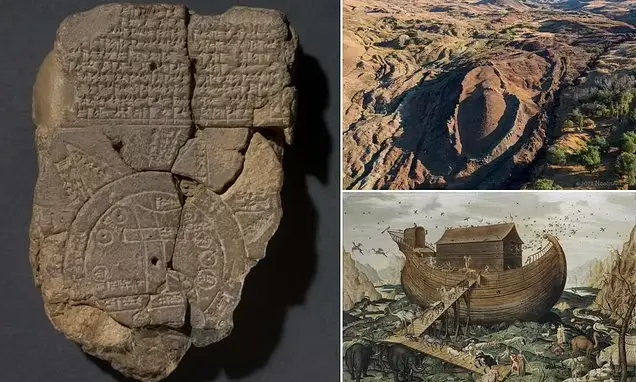
Scientists have deciphered the world’s oldest map etched in a clay tablet about 3,000 years ago, finding it features the location of ‘Noah’s Ark’ among the drawings.
The Babylonian artifact, known as the Imago Mundi, shows a circular diagram with a writing system that used wedge-shaped symbols to describe the early creation of the world.
Researchers at the British Museum, where the tablet is housed, revealed what they had deciphered last month, but a deeper analysis of their work uncovered the Biblical reference within the ancient language.
The back of the tablet acts like a key, describing what a traveler will see on their journey, with one portion says that they must pass through ‘seven leagues… [to] see something that is thick as a parsiktu-vessel.’
The word ‘parsiktu’ has been found on other ancient Babylonian tablets, specifically to explain the size of a boat needed to survive the Great Flood.
Researchers followed the instructions, finding a path to ‘Urartu’ where an ancient Mesopotamian poem claims a man and his family landed an ark to preserve life.
The location is the Assyrian equivalent to ‘Ararat,’ the Hebrew word for the mountain Noah crashed the Biblical vessel that was constructed for the same purpose.
Dr. Irving Finkel, British Museum curator, said: ‘It shows that the story was the same, and of course that one led to the other but also, that from the Babylonian point of view, this was a matter of fact thing.
‘That if you did go on this journey you would see the remnants of this historic boat.’

The Imago Mundi, also called the Babylonian Map of the World, was discovered in 1882 by renowned archaeologist Hormuzd Rassam in Sippar, an ancient Babylonian city in what is now present-day Iraq
CLICK HERE TO READ MORE FROM THE REPUBLICAN VOICE
The Imago Mundi has mystified researchers since it was found in 1882 in what is now known as Iraq.
The ancient text, written in cuneiform, was only used by the Babylonians, who etched astronomical events, future predictions and a map thought to be the entire ‘known world’ at the time.
At the bottom center of the map sits Mesopotamia, enclosed by a circle representing a ‘bitter river’ that was believed to surround the entire world.
The tablet has since been damaged, but once featured eight triangles that researchers determined signified mountains that match descriptions on the back.
‘Number four says ‘To the fourth, to which you must travel seven leagues,” Dr Finkel said in a YouTube video.
He continued to explain that the passage continues to explain how a journeyer will eventually come upon a giant vessel.
‘This parsiktu measurement, is something to an Assyriologist which makes their ears prick and the fact is it’s only once otherwise known from cuneiform tablets and it’s rather an interesting cuneiform tablet too,’ said Dr Finkel.
‘Because it is the description of the Ark which was built, theoretically, by the Babylonian version of Noah.’

The back of the tablet provides instructions on how to read the map. One passages tells the traveler to pass through the sea and they will come to ‘Urartu’ where an ancient Mesopotamian poem claims a man and his family landed an ark to preserve life

The location is the Assyrian equivalent to ‘Ararat,’ the Hebrew word for the mountain Noah crashed the Biblical vessel that was constructed for the same purpose
The Babylonian version of the story says the god Ea sent a flood that wiped out all of humanity except for Utnapishtim and his family, who built an ark at the command of the god and filled it with animals.
‘In this account, the details are given and the God says ‘You have to do this, this and this’ and then the Babylonian Noah says ‘I did this, this and this. I’ve done it! And I made these structures as thick parsiktu vessel,” Dr Finkel.
The Gilgamesh Flood story is known from clay tablets that date back around 3,000 years, the Biblical Flood was about 5,000 years ago.
Dr Finkle explained that anyone who traveled the path to Urartu would, theoretically, see the wooden ribs of the vessel on the mountain ‘like the one in the Bible.’
The Bible claims the ark settled on the ‘mountains of Ararat’ in Turkey following a 150-day flood that drowned the Earth and every living thing on it that was not housed inside the wooden ship.
And the mountain in question features a peak that matches the shape and dimensions of Noah’s ark.
The vessel was said to measure ‘300 cubits, 50 cubits, by 30 cubits’, which translates to up to 515 feet long, 86 feet wide and 52 feet high.
The idea that the ark landed on Ararat has been surrounded by controversy, as some scientists claim the formation was formed by nature and others are sure it came from a higher power.
CLICK HERE TO READ MORE FROM THE REPUBLICAN VOICE
A team of experts led by Istanbul Technical University has been excavating the mountain for years, revealing in 2023 that they found clay, marine materials and seafood that placed humans at the scene between 3,000 and 5,000 years ago.
However, Dr Andrew Snelling, a young Earth creationist with a Ph.D. from the University of Sydney, had previously said that Mount Ararat could not be the ark’s location because the mountain did not form until after the flood waters receded.
Although considered a historical event, most scholars and archaeologists do not believe in literally interpreting the Ark story.
source: dailymail.co.uk/Noahs-Ark-revealed-worlds-oldest-map-Babylonian-tablet


